| This article originally appeared in Geospatial Solutions Magazine's Net Results column of October 1, 2000. Other Net Results articles about the role of emerging technologies in the exchange of spatial information are also online. | |
| 1. Introduction and Glossary 2. Get the Right Shrink 3. Ride the Wave 4. Color Safe or Sophisticated? | |
| Color safe or sophisticated? The compression conundrum is but a single obstacle to displaying images on the Internet. Spatial Web site designers also have to consider their color choices carefully. Have you ever wondered why maps generated by GIS software are so often composed of overly bright and highly contrasting colors? Compared with the sophisticated and highly readable styles of their paper map forefathers, many digital maps fall short cartographically. A possible reason for this lies in the history of computer displays, a history that you can access from your own modern monitor. The next time a cartographer or map-lover raves about his or her favorite digital map's fantastic readability, try the lowest common denominator test. What you'll discover is your friend's personal preference for either readability or accessibility. It's easy to run the test; just open your computer's control panel and reset the display's colors downward one step, then reexamine the digital map. If your cartographic friend usually works in a true 24-bit color environment, step down to 16-bit high color, or lower still to 256 colors. How does the map look now? If you dare, go as low as 16 or just 8 colors. That favorite digital map might survive the switch to 256 colors, but by the time you reach 8, it will likely be unrecognizable. When your friend stops writhing in agony at the sight of his corrupted map, switch to gray-scale or monochrome and watch him gasp his last breath. Figures 6a through 6e illustrate these different ranges of colors on a single USGS image. |
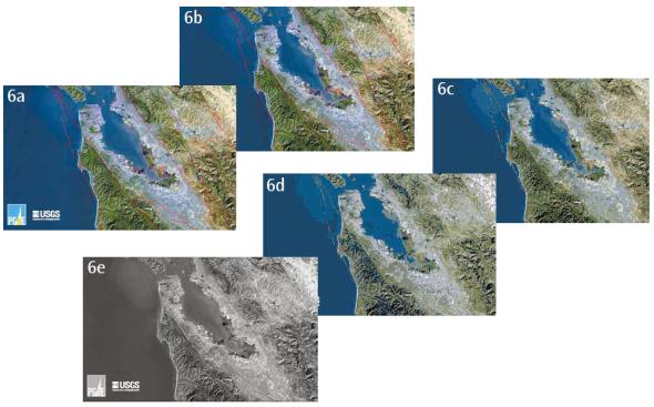 Figure 6A-6E: Decreasing color palettes degrade image quality. The palettes go from true 24-bit color (6a) to 256-colors (6b) to 16-colors (6c) to 8-colors (6d) to grayscale (6d). (Original USGS image from www.sfbayquakes.org/closeups/USLetter/M_sillvall_faults_view.jpg.) |
| The more primitive color palettes used to be the only option, and for some, it still is. Not every Internet surfer has the luxury of a 24-bit color display. Many a public school computer lab administrator is relieved to finally upgrade her monitors from monochrome to 256-color systems. Remembering your Web site's targeted audience may help in setting the lowest common denominator color-palette. Platform matters. In addition to differences in monitors, color representation differs across platforms. One way of representing color digitally is the RGB method. With RGB, every color is the result of adding together a red, green, and blue value, each of which can vary between a range of 0 and 255. Maps that use all the available colors in the 256 color set, or most of the millions of colors available in the True Color set, may contain dithered colors (the mixing of available colors to approximate the color that is not available) or completely different colors when viewed using other browsers or computers. This potential irregularity is due to the fact that 40 colors in the 256 color set vary on Macintosh and PC platforms. Eliminating these 40 colors from the RGB 256 set creates a palette of 216 colors the Web-safe or browser-safe palette guaranteeing that maps look identical on all platforms. With safety, though, comes limitations. Figure 7 shows the Figure 1's symbolic map in its less cartographic Web-safe mode. |
 Figure 7: The symbolic map from Figure 1 remains readable when resampled from 256 colors down to 216 Web-safe colors, but is it graphically stark? |
| Xippix of Larkspur, California, offers a solution to the color problem. A spinoff of Island Graphics, Xippix has studied the image lifecycle from moment of capture on any sort of digital camera or video device, through the editing process, and finally to viewers displays. By creating cookies that contain the specific settings and individual irregularities of their computer monitors, Xippix customers are guaranteed that the colors of every Xippix image match the colors of the originally photographed object. Based upon a cookie s contents, the Xippix image server (also known as Image Pump) modifies its images on the fly before sending them to the cookie s owner. Xippix also offers several Internet-based image viewing tools -- both standard hypertext markup language (compatible with any browser version) and Java (for advanced viewing tools) that reduce the perceived wait time when zooming and panning. The company, for example, has simulated a rotateable, zoomable image application to allow Web users to examine three-dimensional objects in detail, zooming in and out from all available viewing angles. In addition to Web tools, Xippix sells both in-house and hosted solutions for large and small businesses interested in delivering Web-based images to the public. Using a simple uploading tool, registered users can store their images on the Xippix server farm and then refer to them from any Web page on the Internet. The Xippix servers then process the image for color fidelity and send it to the requesting page. Tell 1,000 words using 225 and fast Images transcend language and literacy. The bathymetry of the world's oceans is both instructive and beautiful. By entering my address at a spatial Web site for the city where I work, I can see a 1-foot pixel resolution orthophotograph of my building, clear down to the cars parked along the street and the shadows of the pedestrians. In seconds, I can marvel at a digital terrain model of the entire state of California served to my Web browser by USGS. But none of these wonders would be worth waiting an hour to view. Thanks to these sites designers, the images arrive quickly, read clearly, and perform with the same reliability day after 24-7 day. With a little forethought, some experimentation, and well-chosen commercial tools, any spatial Web site can meet these simple yet critical criteria.
|
| 1. Introduction and Glossary 2. Get the Right Shrink 3. Ride the Wave 4. Color Safe or Sophisticated? |
|
|