|
|
| |||||||||||||||||||||||||||||||||
|
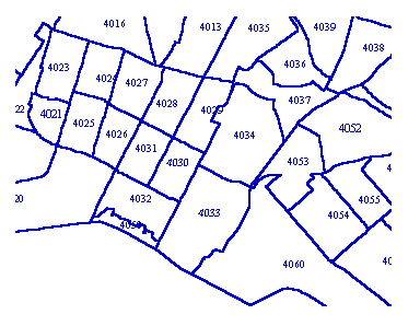
City of Oakland data set: Census Tracts (US, 1990) |
|
 |
Who maintains the data for this layer: Monica Lamboy, CMO Data Maintainer Phone: (510) 238-6855 Who converted the data into a GIS format: Julia Howlett, Jonathan Lowe GIS Technician Phone: unlisted Size of GIS layer (KB): 428 Size of export file (KB): 752 Where is the layer stored (on the k-drive): k:\gisdata\gover\centract.e00 This GIS layer was last updated on: 11/1/96 This metadata was last updated on: 3/20/97 This layer's FGDC category description is: Governmental Units |
|
Data Set Description: This layer contains 1990 US Census Tracts for the City of Oakland. Data from the Standard Tape Files (1 & 3) can be joined to this GIS layer using TRACT as the common item. STF1 and STF3 contain over 3000 possible categories of information about each tract and blockgroup including population, ethnicity, income, and many other demographics. In Oakland, these STF records are available on the AS400 computer (via CityNet). Contact Monica Lamboy for details on STFs. Non-standard Attributes in table:
Data Source History: Teale Data Center supplied OCIS with the original layer. Using Monica Lamboy's (CMO) paper maps, Julia Howlett (JRH Consulting) realigned the tract boundaries to correspond with Oakland's digital orthophoto accuracy requirements (see CENBLOCK). Quality Check: The node-to-node links between the original "tiger" coverage and the conflated "roads" coverage were saved during conflation and used as the control for an arc/info adjust command which shifted the tiger-based Census lines to the coordinate accuracy of the "streets" coverage. This established a general-use coverage. A second quality control process matched each line segment in the census block coverage precisely to its corresponding street centerline or other boundary according to digital orthophotos. Blockgroups and tracts were then created by dissolving by identity items into regions. Julia Howlett, JRH Consulting, performed this second QC step. Security restrictions: No security restrictions Update Frequency: US Census 2000 Update process:
The census layers are snapshots of a single survey and are not updated once created. New census surveys are added to Oakland's GIS collection as separate GIS layers. The next census, 2000, will likely be acquired from the internet when available. |