|
|
| |||||||||||||||||||||||||||||||||
|
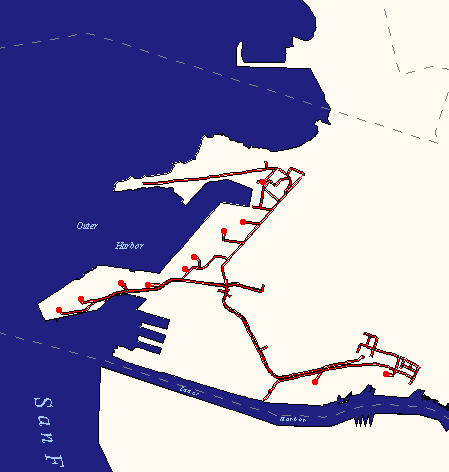
City of Oakland data set: Container Routes permitted in harbor areas |
|
 |
Who maintains the data for this layer: David Adams, Port of Oakland Data Maintainer Phone: (510) 272-1313 Who converted the data into a GIS format: Jake Schweitzer GIS Technician Phone: unlisted Size of GIS layer (KB): 126 Size of export file (KB): 154 Where is the layer stored (on the k-drive): k:\gisdata\trans\cntainrt.e00 This GIS layer was last updated on: 2/22/97 This metadata was last updated on: 3/20/97 This layer's FGDC category description is: Transportation |
|
Data Set Description: This layer contains permitted routes for cargo transport, along with the locations of the terminal gates. For reference to other features of the port, view this data-set with the Harbors layer, the Major Container Freight Stations layer, and/or the Gantry Crane layer (Prt_Crns). Non-standard Attributes in table:
Data Source History: Jake Schweitzer, In Situ Mapping, contacted Dave Adams, Port of Oakland, and was given paper maps and data describing the locations of harbors and marinas. Jake digitized this data in ArcEdit using the digital orthophoto as a reference (the original maps were only reference quality, and were too inaccurate to support standard scan-and-digitize routines). Quality Check: No quality control procedures performed to date. Security restrictions: No security restrictions defined for this data set Update Frequency: No updates scheduled. Update process:
Update process is not yet defined |