|
|
| |||||||||||||||||||||||||||||||||
|
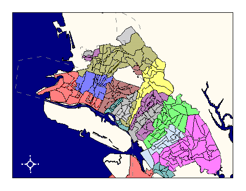
City of Oakland data set: Sewer and Storm Drainage Basins and Sub-basins |
|
 |
Who maintains the data for this layer: Fuad Sweiss, OPW Data Maintainer Phone: (510) 238-6607 Who converted the data into a GIS format: Kyle Draganov GIS Technician Phone: unlisted Size of GIS layer (KB): 420 Size of export file (KB): 656 Where is the layer stored (on the k-drive): k:\gisdata\other\drnbasin.e00 This GIS layer was last updated on: 1/16/96 This metadata was last updated on: 3/20/97 This layer's FGDC category description is: Other (Non-FGDC) |
|
Data Set Description: This Layer contains Sewer and Storm Drainage Basins and Sub-basins; each basin consists of sewer lines which are gravity fed, this layer contains the borders for the gravity fed systems which the city is running. Non-standard Attributes in table:
Data Source History: Drainage Basins and Sub-Basins were digitized using a heads up and scanning of paper "basin" maps from the Office of Public Works, and are only as accurate as the paper maps (1:1500).The maps were provided by the engineering department. Quality Check: Kyle Draganov, of Earthwise Consulting, check layer for Quality by matching intersecting polygons (basins) to the paper map, and in areas of inconsistency verified line work with SSMS books located at OPW. Accuracy of layer to the SSMS books was not specified in the contract. Security restrictions: No security restrictions. Update Frequency: No scheduled updates by OCIS. Update process:
Update process is not yet defined |