|
|
| |||||||||||||||||||||||||||||||||
|
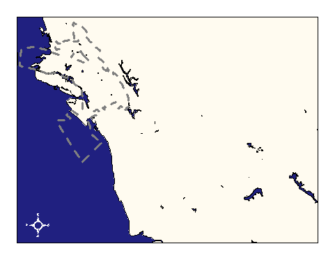
City of Oakland data set: Land and Water Bodies for Alameda County |
|
 |
Who maintains the data for this layer: OCIS GIS Consulting Team Data Maintainer Phone: (510) 238-6855 Who converted the data into a GIS format: Jake Schweitzer GIS Technician Phone: unlisted Size of GIS layer (KB): 606 Size of export file (KB): 1003 Where is the layer stored (on the k-drive): k:\gisdata\hydro\hydro.e00 This GIS layer was last updated on: 2/27/97 This metadata was last updated on: 3/20/97 This layer's FGDC category description is: Hydrography |
|
Data Set Description: This layer contains the boundaries of land and water for Alameda County, not including streams. E.g. Coastlines, reservoirs, islands, etc. Non-standard Attributes in table:
Data Source History: The original dataset was a TIGER product. The water boundaries were isolated using a query on census feature class codes (CFCC) containing "H" (hydrologic features). The resultant layer was edited to contain only polygon outlines. This stripped the stream lines and left only ponds, lakes, reservoirs and the Bay. Finally, Jake Schweitzer, In Situ Mapping, redigitized the TIGER layer along the coast and inland lakes using Oakland's 1:100 scale, 1' pixel resolution orthophotos and a pre-existing marinas data set of boating docks. Quality Check: Upon the adoption of the "streets" coverage and the digital orthophoto as Oakland's standard for coordinate accuracy, the hydro coverage was corrected using the arc/info "adjust" command with parameters based upon the node-to-node links established during the tiger-roads conflation process. This established a general-use hydro coverage. The second phase of conversion entails tracing the coastline and edges of waterbodies visible in the Digital Orthophoto. Jake Schweitzer, In Situ Consulting, updated the hydro coverage for both Oakland and its neighbors. Security restrictions: No security restrictions. Update Frequency: No scheduled updates. Update process:
Update process unknown at present |