|
|
| |||||||||||||||||||||||||||||||||
|
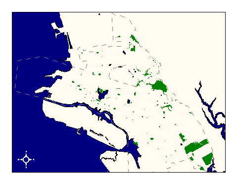
City of Oakland data set: Parks |
|
 |
Who maintains the data for this layer: Martin Mataresse, J. Ryugo OPR Data Maintainer Phone: (510) 482-7857 Who converted the data into a GIS format: Kyle Draganov GIS Technician Phone: unlisted Size of GIS layer (KB): 400 Size of export file (KB): 742 Where is the layer stored (on the k-drive): k:\gisdata\other\parks.e00 This GIS layer was last updated on: 12/16/96 This metadata was last updated on: 3/20/97 This layer's FGDC category description is: Other (Non-FGDC) |
|
Data Set Description: This layer contains parks and open space owned or maintained by the City of Oaklands office of parks and recreation. Non-standard Attributes in table:
Data Source History: Martin Mataresse (OPR) supplied Kyle Draganov (Earthwise Consulting) with a paper spread sheet listing park APN's. Kyle then found the park boundaries by querying the citywide GIS parcel layer for all APN #'s in Martin's list. Martin provided Kyle with assessor's parcel maps in cases where list entries did not produce a match in the GIS parcel layer. Parks and open space maintained by OPR were selected by Assesors Parcel Numbers and then checked for missing area. Some park parcels were not yet part of the citywide parcel layer; Kyle hand-digitized (using edge of pavement as a guide). In cases where no physical property line was available, Kyle did not digitize the park to ensure that incorrect data would not be used. Quality Check: Jim Ryugo, OPR, reviewed the results of the parks digitizing and listed missing parks in an excel spreadsheet. Kyle added the parks with ArcEdit tools. Security restrictions: No security restrictions Update Frequency: Update as often as property changes hands with OPR or as deemed fit by the data custodian. Update process:
Update process is not yet defined |