|
|
| |||||||||||||||||||||||||||||||||
|
City of Oakland data set: Streets resurfaced within the past 5 years |
|
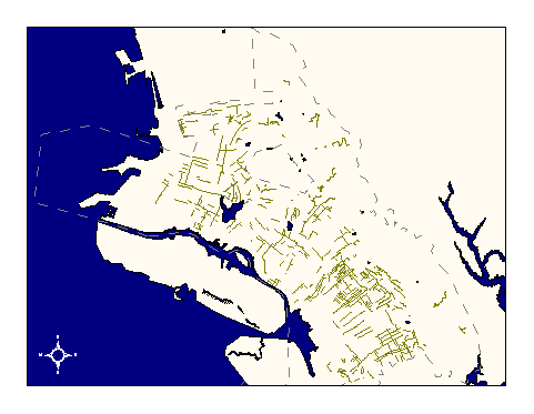 |
Who maintains the data for this layer: Fuad Sweiss Data Maintainer Phone: (510) 238-6607 Who converted the data into a GIS format: Kyle Draganov GIS Technician Phone: unlisted Size of GIS layer (KB): 330 Size of export file (KB): 608 Where is the layer stored (on the k-drive): k:\gisdata\trans\rsurface.e00 This GIS layer was last updated on: 1/31/97 This metadata was last updated on: 3/20/97 This layer's FGDC category description is: Transportation |
|
Data Set Description: No data set description available. Non-standard Attributes in table:
Data Source History: Fuad Sweiss, OPW, supplied Kyle Draganov, Earthwise Consulting, with a .dbf file containing starting and ending points for all streets in Oakland that had been resurfaced within the past five years. Kyle then geocoded the start- and end-points into paired from- and to- nodes suitable for automated routing. He routed all pairs, finding the shortest cost path between each pair and built the resulting network coverage as an arc coverage. Some addresses in the original .dbf did not successfully geocode due to non-compliance with Oakland address standards. These non-matches were not manually corrected. Approximately 20% of the resurfaced streets in the original .dbf file are therefore not represented in the final GIS layer. Quality Check: Kyle Draganov performed a visual quality check of successfully geocoded and routed arcs and noted any errors. These errors will be repaired at the request of OPW. Non-geocoded addresses will be manually corrected or edited in the original .dbf file at the request of OPW. Security restrictions: no restrictions Update Frequency: annually or as often as streets are resurfaced. Update process:
No update process is yet defined. |