|
|
| |||||||||||||||||||||||||||||||||
|
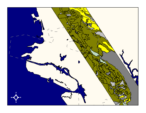
City of Oakland data set: Soil composition by series and type |
|
 |
Who maintains the data for this layer: Prof. John Radke, AEGIS lab Data Maintainer Phone: (510) 643-5995 Who converted the data into a GIS format: Jonathan Lowe GIS Technician Phone: unlisted Size of GIS layer (KB): 516 Size of export file (KB): 1049 Where is the layer stored (on the k-drive): not available on k-drive This GIS layer was last updated on: 5/15/96 This metadata was last updated on: 3/20/97 This layer's FGDC category description is: Other (Non-FGDC) |
|
Data Set Description: The soils layer shows boundaries between different soil types in the East Bay Hills study area between San Leandro and El Cerrito. AEGIS lab description: "Soils..help predict erosion, ground stability, and vegetation potential." Non-standard Attributes in table:
Data Source History: AEGIS lab description: "The initial soils data gathered for this study was provided by the US Department of Agriculture Soil Conservation Service (SCS). The data was the soil series published by the SCS. Parts of seven USGS 7.5 minute quadrangles from Zone 3 (1:24,000 scale) maps were needed to define the study site. The data was received both in paper copy format and scanned digital raster format (on an 8 mm tape). The SCS is currently engaged in a massive project to reclassify the soil series for the entire country. The original printing plates delineating the soil polygons were scanned by the SCS. Data Processing--The scanned images were vectorized and input into Arc/Info format. Since the image was not geo-referenced the resultant vector data had to be transformed into the UTM coordinate system used in the study. The scanned images contained areas which had superfluous data and other areas which contained no data at all. These problems were corrected using Intergraph's Microstation digital mapping software. The unnecessary data was deleted and missing lines and polygons were added from the information provided from hard copy maps. Once each map sheet was ready, they were joined into one final layer or coverage. The individual soil polygons were then numbered, and labeled with their corresponding soil types. Soil attribute data was collected from the USDA Soil Conservation Service Surveys of Alameda and Contra Costa Counties. This information was put into a data base using dBASE III and then bulk loaded to INFO. The soil attribute table contains; soil type, soil series, acidity (pH), permeability, water contents, hydrologic soil group and engineering capability. Data Output--The output from this data set is a set of polygons with each polygon representing a polygon from the county soil series. Characteristics about each polygon are stored in a data table which is linked to the coverage." The data was received as an Arc/Info coverage in UTM projection, NAD27. Jonathan Lowe (LKC) converted it into Cal Stateplane, NAD83, units feet, using Arc/Info's projection utility and two custom AML's called "utm2spc.aml" and "nad2783.aml." Quality Check: No quality control procedures yet performed on this layer. Security restrictions: City of Oakland use only Update Frequency: No updates scheduled Update process:
Update process is not yet defined |