|
|
| |||||||||||||||||||||||||||||||||
|
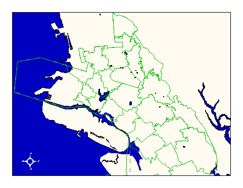
City of Oakland data set: Fire Still Districts (alias: Fire Response Radii) |
|
 |
Who maintains the data for this layer: Capt. Mike Kelly, OFD Data Maintainer Phone: (510) 238-4038 Who converted the data into a GIS format: Jonathan Lowe, Julia Howlett GIS Technician Phone: unlisted Size of GIS layer (KB): 288 Size of export file (KB): 468 Where is the layer stored (on the k-drive): k:\gisdata\gover\stildist.e00 This GIS layer was last updated on: 7/3/95 This metadata was last updated on: 3/20/97 This layer's FGDC category description is: Governmental Units |
|
Data Set Description: Still districts are radii of response for engine companies and are used to make dispatch decisions. For example, if a fire occurs in still district #7, then engine company #7 will respond to the fire if they are not otherwise engaged. Non-standard Attributes in table:
Data Source History: Capt. Mike Kelly, Oakland Fire Department, delivered a Rand-McNally paper map to OCIS. Capt. Kelly had outlined the still district boundaries on the paper map using a highlighter pen. Jonathan Lowe (LKC) digitized these boundaries using the street network as a reference between the paper map and the GIS environment. Since boundaries of stildistricts often follow street centerlines, there was no need for heads-up digitizing. Quality Check: Upon completion of the parcel GIS layers, Julia Howlett (JRH Consulting), revised the still districts layer such that district lines following back lot lines corresponded to the back lot line parcel boundaries. Security restrictions: No security restrictions. Update Frequency: No updates scheduled Update process:
Update process is not yet defined |