| Go forth and multiply
Although the individuals that make up the potential mobile device and LBS marketplace may be similar, market figures from different cultures suggest that we have not all achieved our potential at the same rate or in the same fashion. Clearly, variations in culture, technical standards, economics, demographics, and geography result in different buying and usage patterns for mobile devices from one region or country to another.
Japanese market. In Japan, for instance, mobile devices are staggeringly popular. According to Japan's Telecommunications Carriers Association, there are more than 61 million handset users in Japan and about half of the Japanese population are wireless subscribers. The group says wireless access to the Web contributes significantly to the growth of their industry. NTT DoCoMo (www.nttdocomo.co.jp) is the Japanese market leader with more than 34 million subscribers.
In Japan, LBS solutions in actual use are the Zenrin Mobile Map, built for NTT DoCoMo by Zenrin Co., Ltd. (www.zenrin.co.jp) and Cybird Co., Ltd. (www.cybird.co.jp); and the J-Navi service (www.j-navi.com), built for J-Phone (www.j-phone.com) by Xmarc (www.xmarc.com). Mobile Map uses residential maps with the building footprints clearly displayed as the primary locational reference (see Figure 3). Regarding the userinterface challenges of maps on tiny mobile phone displays, Zenrin states, "with more than 100,000 pieces of map information covering restaurants, leisure facilities, and public facilities all over Japan, searching is a breeze. It s one information service you don t want to leave home without." |
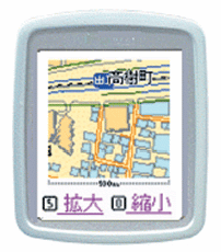 |
| Figure 3: This sample user interface from the NTT DoCoMo Zenrin Keitai map service shows building footprints, landmarks, streets, and a scale bar. |
| Europe. Europe also reports impressive market penetration figures -- around 50 percent in some countries. Stories from telecommunications operators throughout the continent give a flavor of the European wireless market. For instance, Airtel (www.airtel.es), Spain's second-largest telecommunications service, has six million customers and generates approximately $2 billion in annual revenue after five years of operation. Another telecom giant in France, Cegetel (www.cegetel.fr), boasts more than 7.3 million subscribers and had sales of $3 billion in 1998. The Netherlands telecom, KPN (www.flexibel.com), has about two million mobile customers, both at home and abroad. These companies represent only the tip of the telecom iceberg. Overall, the European Union's annual Telecoms Report confirms that communications remains a significant economic driver, and values Europe's combined telecom markets at 191 billion euros (U.S. $182 billion) in 2000. Significant, indeed.
The European approach is well represented by a company called Webraska (www.webraska.com), an LBS solutions-provider based in Poissy, France. Webraska promises clients that its solutions will increase revenue, reduce customer turnover, and increase operational efficiency. To that end, the firm acquires, quality controls, and integrates international cartographic data and real-time traffic information into a standard query language database and sells both turnkey services based on routing and proximity queries of their collection. As an integrator of existing digital mapping data suppliers, Webraska serves 13 European countries as well as the United States and Canada. The company s database contains 18 million kilometers of road, 350,000 towns and cities, and more than 400,000 points of interest spanning Austria, Belgium, Denmark, France, Germany, Italy, Luxembourg, The Netherlands, Portugal, Spain, Sweden, Switzerland, and the United Kingdom. Webraska also delivers three services to wireless operators interested in creating applications using its data collection: turn-by-turn directions, proximity services, and traffic maps. Turn-by-turn directions are text descriptions of the optimum route and journey time based on current traffic conditions for those traveling on foot or by car, bicycle, bus, metro, or train. Text directions may be accompanied by dynamically-generated, zoomable, turn-by-turn maps. Start point and destination are entered using the telephone keypad. Directions account for one-way streets and pedestrian access to and from public transportation. Proximity services enable subscribers to search for nearby points of interest and services such as ATMs, train stations, hospitals, car parks, bus stops, museums, monuments, gas stations, and public services (see Figure 4), which are ranked in terms of journey time from the subscriber s start point. Of course, turn-by-turn directions to the chosen destination are also available. Traffic maps help subscribers avoid congestion and save time by displaying current traffic conditions on predefined maps (see Figure 5). Webraska traffic maps already exist for six countries and classify traffic as fluid, slow, or stationary by shading the routes. |
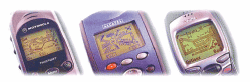 |
| Figure 4: Each of these phones displays the product of a proximity search by three different vendors' mobile devices and in two different languages (left most in English, right two in French) from Webraska's Web site (www.webraska.com). |
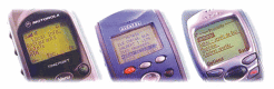 |
| Figure 5: Traffic congestion and routing maps displayed on three different vendors' mobile devices from Webraska's Web site. |
| The creation story. Also selling to programmers, Webraska offers a Personal Navigation API that enables developers to integrate navigation, mapping, and spatial searching functionality into their mobile Internet applications. The API functions are geocoding, reverse-geocoding, positioning, map image output, routing, and ranking of potential destinations in terms of journey time from departure point. Specific to mobile devices, the positioning function confronts the problem of pinpointing a moving user by converting approximate latitudelongitude coordinates into a range of possible addresses. Just as mobile devices are like stripped-down desktop computers, Japan and Europe s LBSs are like compressed network analysis GISs. Then there's the U.S. market... |
|